


LA FERTE SOUS JOUARRE - COULOMMIERS

NUITEVEN
User
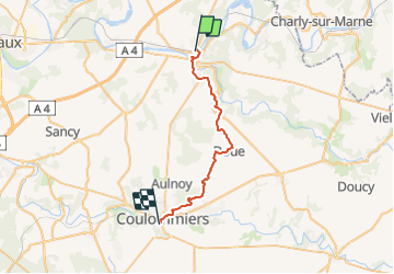

Length
27 km

Max alt
177 m

Uphill gradient
410 m
Km-Effort
32 km

Min alt
51 m

Downhill gradient
402 m
Boucle
No
Creation date :
2018-04-17 10:39:26.358
Updated on :
2018-04-17 10:39:26.358
6h55
Difficulty : Easy

FREE GPS app for hiking
 SityTrail
IGN / Geographical institutes
SityTrail Plus
The world is yours!
About
Trail Walking of 27 km to be discovered at Ile-de-France, Seine-et-Marne, La Ferté-sous-Jouarre. This trail is proposed by NUITEVEN.
Positioning
Country:
France
Region :
Ile-de-France
Department/Province :
Seine-et-Marne
Municipality :
La Ferté-sous-Jouarre
Location:
Unknown
Start:(Dec)
Start:(UTM)
509179 ; 5421976 (31U) N.
Comments